|
|
|
|
AGU Fall, 2001 GPS Measurement of Tectonic Deformation and Isostatic Rebound in Marie Byrd Land, AntarcticaA. Donnellan and B. P. Luyendyk |
|
|
The Ross embayment and western Marie Byrd Land are part of the West Antarctic rift system. The region is undergoing active deformation, but the rates and causes of deformation are essentially unknown. In December 1998 we installed three continuous and autonomous global positioning system (GPS) stations on outcrops in western Marie Byrd Land, with baselines between stations of about 100 kilometers. We recovered data for the sites in Marie Byrd Land during the 1998/1999 season and additional data in November 1999, November 2000, and January 2001. Results from three years of data collection indicate essentially no extension between McMurdo station (MBL4) and the network. The results show an overall length rate of 0.7 +/- 3.5 mm/yr between MCM4 and the wMBL network. With additional years of measurements we should be able to discriminate whether this rate is near zero or not to about 1~mm/yr. We also expect to detect strain gradients within wMBL. The network also suggests a dome of uplift centered near the Rockefeller Mountains, with the maximum rate being in the Rockefeller Mountains of 12 +/- 8 mm/yr. This is consistent with proposed post-glacial rebound for the region. The strain data from wMBL and the Transantarctic Mountains will enable us to construct models for tectonic extension and glacial rebound in the West Antarctic rift. The results will help determine whether active tectonic deformation is occurring in the Ross embayment. Crustal uplift could be occurring in western Marie Byrd Land due to isostatic rebound following the last glacial age. Tectonic extension, occurring in the embayment, could greatly influence global plate circuit calculations and constrain our understanding of the history of extension in the embayment and the consequent uplift history of the Transantarctic Mountains. |
|
|
Tectonics, 2001Structural and tectonic evolution of the Ross Sea rift in the Cape Colbeck region, Eastern Ross Sea, Antarctica
|
|
|
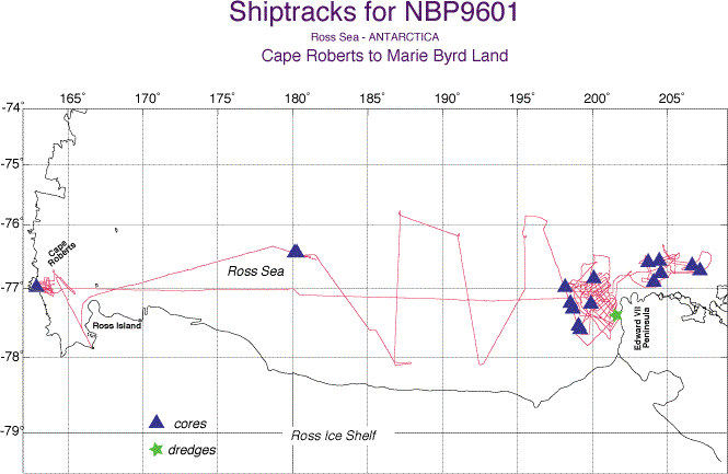
The far eastern continental shelf of the Ross Sea, Antarctica, has been relatively unexplored up to now. This region and western Marie Byrd Land are at the eastern limit of the Ross Sea rift, part of the West Antarctic rift system, one of the larger regions of extended crust in the world. The Ross Sea continental shelf west of Cape Colbeck and the Edward VII Peninsula in western Marie Byrd Land was investigated using marine geophysics during cruise 9601 of the RVIB Nathaniel B. Palmer. The purpose was to determine the structural framework and tectonic history of the eastern border of the Ross Sea rift and to integrate this with what is known about western Marie Byrd Land. The region mapped is characterized by a passive margin with a flat over-deepened shelf cut by the north-trending Colbeck Trough, an erosional feature formed in Miocene and later time by glacial downcutting that followed the locations of existing basement structures. Seismic sequences and unconformities identified in the Ross Sea were correlated into the Colbeck shelf area. The section comprises mostly undeformed glacial marine sequences of Late Oligocene and younger age that are unconformably overlying late Early to Late Cretaceous and minor Early Tertiary (?) faulted sequences. This unconformity is identified as RSU6, mapped elsewhere in the eastern Ross Sea. Two units are found below RSU6, each separated by an unconformity that is here named RSU7. These sequences fill north trending half-grabens in the faulted basement and are interpreted as syn-rift units. Unconformity RSU7 is correlated to the West Antarctic Erosion Surface mapped onshore in western Marie Byrd Land. The lack of thick Early Tertiary sediments on the shelf suggests significant vertical tectonics. This onshore and offshore region was widely faulted in late Early and Late Cretaceous time, was high above sea level and was beveled by prolonged erosion, while subsiding steadily in Late Cretaceous and Cenozoic time. Subsidence was largely due to lithosphere cooling amplified later by glacial and sediment loading in Cenozoic time. Mylonites that have late Early Cretaceous cooling ages were dredged from the southeast wall of the Colbeck Trough. This finding and normal faults that we mapped in the eastern Ross Sea we attribute to detachment -style extension in late Early Cretaceous time. This extension was directed subparallel to the trend of the present margin edge and occurred prior to the rifting of Campbell Plateau from Marie Byrd Land at about 79 Ma. Cooling events onshore western Marie Byrd Land suggests the main extension began at about 105 Ma. This is also the time of transition from subduction to extension elsewhere along the ancient Gondwana margin. Minor west tilting of the shelf during the Late Cenozoic was the result of continued subsidence of the continental shelf along with possible uplift of western Marie Byrd Land associated with the Marie Byrd Land dome to the east. Early Tertiary extension in the western Ross Sea rift is not strongly reflected in the east side of the rift. A more robust correlation of the events here with the better-known tectonic history on the west side of the Ross Sea rift awaits sampling and dating of the units we mapped on the Colbeck shelf.. |
|
|
Tectonics, 2001 Cenozoic tectonics of the Cape Roberts Rift Basin and Transantarctic Mountains Front, Southwestern Ross Sea, Antarctica
|
|
|
We conducted a multichannel seismic reflection survey offshore Cape Roberts, Antarctica, and combined our findings with the results of the Cape Roberts International Drilling Project (CRP). This allows us to interpret Cenozoic tectonics in the southwest sector of the Ross Sea including the history of uplift of the Transantarctic Mountains (TAM) and subsidence of the Victoria Land Basin (VLB). Seismic stratigraphic sequences mapped offshore Cape Roberts are tilted eastward and thicken into the VLB where they comprise more than half the fill seen on seismic records. Normal faults a few kilometers offshore cut these sequences and define a north trending rift graben. Drilling results from the CRP show that these strata are latest Eocene (?), Oligocene, and younger in age; much younger than previously inferred. We interpret this pattern to be due to an episode of E-W extension and related subsidence that occurred across the major basins in the western Ross Sea during the early Cenozoic. The rift graben offshore and adjacent to Cape Roberts is bounded on the west by a major north trending fault zone. At Cape Roberts this fault system may have from 6 to 9 km of vertical separation. This fault system is part of a larger zone along the coastline in southern Victoria Land that accommodated uplift of the TAM in Oligocene time. We name it here the McMurdo Sound Fault Zone. A late Oligocene angular unconformity that is seen in seismic data and sampled by CRP drilling marks the end of east tilting of the stratigraphic sequences. We interpret this as the end of the main uplift of the TAM coinciding with a change from E-W extension to NW-SE oblique rifting at that time. Uplift of the TAM and subsidence in the VLB may be linked with seafloor spreading on the Adare Trough to the northwest of the Ross Sea between 43 and 26 Ma. This would imply a plate boundary between East and West Antarctica crossing through the western Ross Sea in Eocene and Oligocene time.. |
|
|
AGU Fall 2001 Eastern Boundary of the Ross Sea Rift Located in Western Marie Byrd Land, Antarctica Luyendyk, B.P., Douglas S Wilson and Christine S Siddoway |
|
|
We propose that the eastern boundary of the extended crust comprising the Ross Sea rift is located in the northern Ford Ranges of western Marie Byrd Land (wMBL). It is found 250 to 300 km NE of the grounding line of Edward VII Peninsula bordering the far eastern Ross Sea. The Ross Sea rift is part of the West Antarctic Rift system separating East and West Antarctica and is occupied by the Ross Sea continental margin. Extension here occurred mainly in Cretaceous time. Data that support this interpretation include geologic studies in the Ford Ranges, marine geophysical observations in the easternmost Ross Sea, and aerogeophysics of wMBL flown by SOAR. Modeling of marine, land, and airborne gravity data infer that the crust thins by 6 to 8 km from the Phillips Mountains southwest to the eastern Ross Sea with half of the thinning in the northern Ford Ranges and half between the southwest side of the Edward VII Peninsula and the Ross Sea continental shelf. The Fosdick Mountains in the northern Ford Ranges comprise migmatites of the middle crust exhumed between 100 and 94 Ma. The Phillips Mountains north from there and across the Balchen glacier (and basin) are across the rift boundary. Mountains of the Ford Ranges trend NW to E-W. Sub-ice basement mapped by airborne radar comprises NW trending basins and ranges with a relief of 1km or more at a spacing of 20 to 30 km. Basement of the continental shelf of wMBL and the far eastern Ross Sea is faulted into ridges and basins with similar trends and spacing. These basins have provided pathways for glaciers and ice streams that have carved troughs into the continental shelf (e.g., Colbeck Trough west of Edward VII Peninsula). Faults on and offshore strike oblique to the trend of the passive margin. Basement cooling data from onshore suggest that extension began at 105 Ma coincident with a change from subduction to extension in this sector of Gondwana. The extension was oriented northeast as opposed to northwest when Campbell Plateau rifted from West Antarctica. Eastern Ross Sea and wMBL extension is likely related to Australia-Antarctic rifting in Early Cretaceous time. |
|
|
AGU Fall 2001 Geophysical Observations Supporting Significant Variation in ice Thickness of Western Marie Byrd Land, Antarctica Wilson, Douglas S., Bruce P. Luyendyk, Christopher C. Sorlien, and John Stone |
|
|
Several glacially carved troughs with depths exceeding 1 km below sea level have been mapped using sonar in the continental shelf offshore from western Marie Byrd Land. Additional troughs are inferred from gravity anomalies mapped by airborne geophysics over the Sulzberger Ice Shelf. Especially significant is a trough under the northern Sulzberger Ice Shelf, continuing downstream from the Hammond Glacier, with modeled maximum depths of 2.1-2.4 km. Modern ice near most of these troughs is not thick enough for ice to ground at their deepest points by simple lowering of sea level. Because many of these troughs are carved in crystalline basement, many glacial advance/retreat cycles are required to carve the troughs to their observed depths, and ice thickness over most of the drainage areas must have repeatedly been many hundreds of meters greater than the present thickness. Other evidence indicates substantial change in erosion style over the Neogene. Using airborne radar, we have mapped a smooth plateau in the bedrock surface under grounded ice of the Shirase Coast at depths mostly 300-400 m below sea level. Our coverage shows this plateau is 50-75 km wide and extends at least 250 km from near the end of Ice Stream E at 143W to Prestrud Inlet at 156W. We mapped a similar plateau in the Ross Sea southwest of Cape Colbeck. Seismic data in the Ross Sea show the plateau surface eroded into units as young as 19-24 Ma glacial marine sediments, identified by correlation to DSDP Site 270. One possible interpretation is that the plateau was beveled by an earlier form of Ice Stream E, before incision of its present bed 200-400 m lower. A speculative alternative interpretation is that the plateau surface formed by subaerial and wave-base erosion at a fairly ice-free time, probably during Middle Miocene time. |
|
|
AGU Fall 2000 Preliminary Results From an Aerogeophysical Survey of Western Marie Byrd Land, Antarctica Wilson, Douglas S., Luyendyk, B. P. , Siddoway, C. S. , and M. Davis |
|
|
During the 1998-1999 field season, the SOAR project of NSF-OPP and UTIG flew a survey of western Marie Byrd Land measuring surface elevation, ice thickness, magnetics, and gravity over an area extending 470 km (NE-SW) b;y 350 km (NW-SE). The survey area included most of the Shirase Coast and adjacent Ross Ice Shelf, the Sulzberger Ice Shelf, the Ford Ranges, and parts of Ice Stream E and the Edward VII Peninsula. Track spacing over most of the area was 5.3 or 10.6 km. The bedrock surface derived from elevation and ice-thickness measurements shows a remarkably smooth sub-ice plateau extending about 50 km inland from the Shirase Coast (lon. 143-157W) at an elevation of 250-300 m below the WGS84 reference ellipsoid. Northeast of this plateau, the roughness of the bedrock surface increases steadily, locally reaching 2 km relief. Southeast of the Sulzberger Ice Shelf, in the center of the survey area, the bedrock surface has a very linear ridge and trough pattern oriented NW-SE, with 1.0-1.5 km relief and about 25-km ridge spacing. To the north, troughs between the E-W trending ridges of the northern Ford Ranges reach depths of -500 to -1000 m. Interpretation of gravity anomalies over the Sulzberger Ice Shelf indicates the presence of two major NW-trending troughs in the bedrock surface with depths of about -1000 m. Magnetic anomalies of variable but generally low amplitude indicate that more than half of the area is underlain by weakly magnetic basement, but that local sources of moderate to high magnetization are scattered throughout the area. High-amplitude (500-1000 nT), short wavelength anomalies suggestive of significant volcanic centers are common east of the northern Ford Ranges. |
|
|
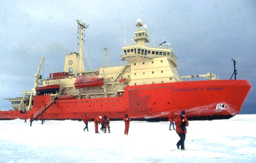
Ice breaker Nathaniel B. Palmer in the sea ice in McMurdo Sound (photo C. Alex)
 Full Size Image |